The Australia Control Map: Unlabeled is a category.geography Montessori material designed for children aged 3-6, crafted by Nienhuis Montessori to AMI standards.
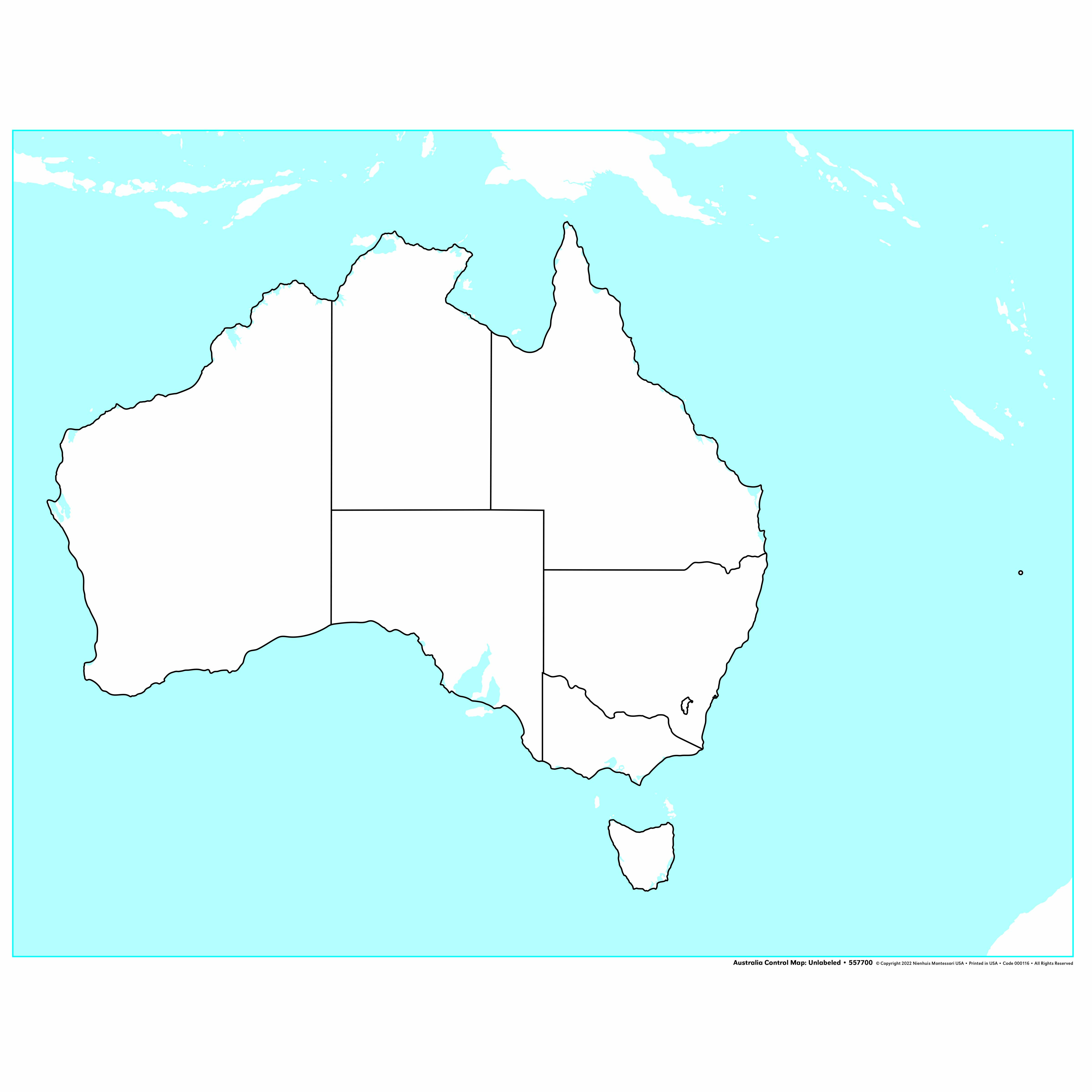
This unlabeled control map of Australia presents the continent with clearly defined state and territory boundaries, serving as a key reference tool for geography work. The laminated surface allows children to trace boundaries with their fingers while learning the distinctive shapes of each region, including Tasmania shown as a separate landmass.
“Education is a natural process spontaneously carried out by the human individual, and is acquired not by listening to words but by experiences upon the environment.”— Maria MontessoriEducation for a New World
“The child is both a hope and a promise for mankind.”
— Maria Montessori, Education and Peace
The unlabeled control map of Australia serves as a foundational geography material by presenting only essential visual information - the continent's outline and internal boundaries. This deliberate absence of labels on the Australia map allows children to focus purely on shape recognition and spatial relationships without the distraction of text. The laminated surface of this control map invites repeated finger tracing, enabling children to internalize Australia's distinctive coastal contours and state boundaries through tactile experience. By offering Tasmania as a separate landmass, the map respects geographical accuracy while teaching children that nations can include disconnected territories. This unlabeled format transforms the Australia map from a passive reference into an active learning tool where children must rely on visual discrimination rather than reading skills. The control map's role extends beyond mere identification - its clear boundary lines help children understand how humans organize geographical space into political divisions while maintaining awareness of the continent's natural form.
Each order includes everything needed for proper presentation and long-term use.
Follow the Montessori method of presentation for optimal child development.
Invite the child to explore Australia's outer coastline with their index finger, starting at any point and moving slowly around the entire continent
Focus on one state or territory, tracing its complete boundary while noting how it connects to neighboring regions
Trace Tasmania's outline separately, then discuss its position relative to mainland Australia
Challenge the child to close their eyes and visualize a specific state shape, then open and trace it
Every material is carefully selected for durability, safety, and authentic Montessori experience.
Sourced from sustainably managed European forests. Beechwood is chosen for its exceptional durability, smooth grain, and natural warmth that invites touch.
Natural, unbleached cotton in child-friendly colors. The fabric provides the right amount of friction for developing fingers while being gentle on sensitive skin.
Water-based, child-safe finish that meets the strictest European safety standards. Designed to withstand years of daily use without chipping or peeling.
Each material supports multiple areas of child development simultaneously.
Develops understanding of political boundaries and spatial relationships within Australia.
Strengthens ability to recognize and distinguish between different state and territory shapes.
Unlabeled format encourages label matching and reading readiness activities.
Builds foundation for learning about Australian geography and regional diversity.
Designed for child-sized hands
Professional tips from AMI-trained guides to maximize the educational value of this material.
“Store the control map flat or gently rolled to prevent creasing that could confuse boundary lines”
Pair this map with sandpaper land and water forms to connect abstract boundaries with physical geography concepts
Create tracing paper overlays for children to practice drawing state boundaries independently
Use the map during group lessons to play boundary recognition games without requiring reading skills
Everything you need to know about this material.
This map is designed for children ages 3-6 years old, aligning with the Montessori early childhood curriculum for introducing geography concepts and spatial awareness.
The unlabeled design follows Montessori principles of isolation of difficulty. Children can focus solely on the shapes and boundaries of states/territories without text distractions, making it ideal for tracing work and shape recognition before introducing names.
The map features a laminated surface that is durable and easy to clean. This allows children to trace boundaries with their fingers repeatedly without damage, supporting tactile learning and fine motor development.
This control map serves as a reference tool that pairs with puzzle maps, pin maps, and labeling activities. Children can use it to check their work, trace outlines for map-making, or as a guide when learning state and territory names.
Yes, the map displays all Australian states and territories with clearly defined boundaries. Tasmania is shown as a separate landmass, helping children understand Australia's complete geographical composition.
Can't find what you're looking for?
Contact Our Experts
Share your experience with this material and help other educators and parents.


