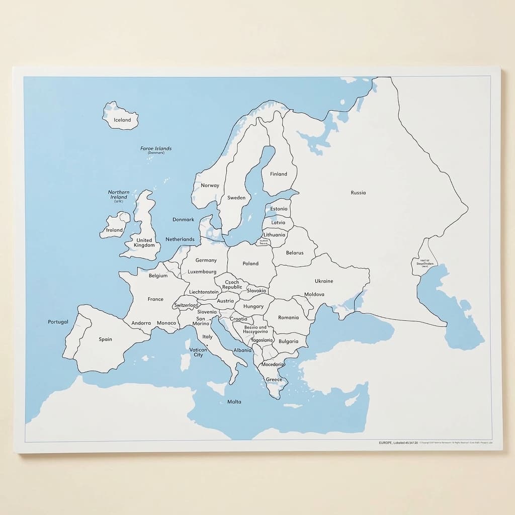
Europe Control Map: Labeled
The labeled control map for Europe, with the country names printed on it. A control map earns its place on a continent with this many names: the child lays out the puzzle map, places what they know, then goes to the printed sheet to settle the rest, and nobody has to be asked for the answer. The unlabeled map, the printed labels and the puzzle map are separate items, which is worth knowing before ordering one sheet. Laminated print.
“The senses, being explorers of the world, open the way to knowledge.”
The Europe Control Map: Labeled represents Montessori's concrete approach to abstract geographical concepts, providing children with a visual reference that bridges their sensorial work with puzzle maps to abstract understanding of political boundaries. This laminated control map serves as a self-correcting tool, allowing children to independently verify their placement of puzzle pieces while building mental images of European nations. By offering clear labels for countries and water bodies, this control map respects the child's need for order and precision during the sensitive period for language and spatial relationships. The Europe Control Map transforms geography from memorization into active discovery, where children can trace borders, compare sizes, and observe relationships between neighboring countries. Its durable laminated surface withstands repeated handling as children return to verify their work, building confidence through successful self-correction.
- Recognizes and names European countries through visual matching with puzzle pieces
- Develops spatial awareness by understanding relative positions of nations and water bodies
- Builds independence through self-correction when working with Europe puzzle map
- Strengthens reading skills by associating country shapes with their written names
Read More
This labeled map embodies the Montessori principle of isolating difficulty, presenting political boundaries clearly while children are still developing their understanding of abstract geographical concepts.


How to present it
Follow the Montessori method of presentation for optimal child development.
Place the Europe Control Map on a table or hang at child's eye level. Ensure the Europe puzzle map is available nearby. Have a pointer or pencil ready for tracing.
- 1
Invite the child to bring the Europe puzzle map to the work area near the control map
Let the child choose whether to work on a rug or table based on their preference - 2
Remove puzzle pieces one at a time, placing them on the work surface
Start with larger, distinctively shaped countries like Spain or Italy for early success - 3
Select a puzzle piece and find its match on the control map by comparing shapes
Encourage tracing the outline on the control map with a finger before matching - 4
Read the country name on the control map together
Point to each letter as you read, supporting left-to-right tracking - 5
Place the puzzle piece in its correct location, using the control map to verify
If incorrect, guide the child to look at neighboring countries for clues - 6
Continue until all pieces are placed, checking each against the control map
Take breaks if needed, this work requires sustained concentration
Every Child Is a Little Creator
Heritage
Since 1929
Brands used by
schools worldwide
European brands
AMI
Endorsed
Related Materials