The Four Maps Of South America is a category.geography Montessori material designed for children aged 3-6, crafted by Nienhuis Montessori to AMI standards.
This comprehensive set of four puzzle maps introduces children to the political and physical geography of South America through hands-on exploration. Each wooden map features removable country pieces that help children develop spatial awareness while learning to identify nations, capitals, and flags through accompanying cards and labels.
“Education is a natural process spontaneously carried out by the human individual, and is acquired not by listening to words but by experiences upon the environment.”— Maria MontessoriEducation for a New World
“The child is both a hope and a promise for mankind.”
— Maria Montessori, Education and Peace
The Four Maps of South America set serves as a concrete bridge between the child's immediate environment and the vastness of our world. Each wooden puzzle piece represents a real country, transforming abstract political boundaries into tangible objects children can hold, trace, and place. The removable country pieces allow repetitive manipulation, satisfying the young child's need to perfect movements while building geographic knowledge. These maps progress from simple continent outlines to detailed political divisions, matching the child's expanding capacity for discrimination and classification. The accompanying cards and labels provide precise language at the moment of greatest interest—when the child has just fitted Brazil or Argentina into its proper place. This systematic exploration of South America's geography through puzzle work addresses the child's need to understand their place in the world through concrete, sensorial experiences.
Each order includes everything needed for proper presentation and long-term use.
Follow the Montessori method of presentation for optimal child development.
Invite the child to remove all pieces from the map, placing them randomly on the mat
Select one piece and slowly trace its outline with two fingers, then trace the corresponding space in the map frame
Place the piece in its location, pressing gently to ensure proper fit
Continue with remaining pieces, allowing the child to work at their own pace
Once complete, introduce country name labels, matching them to the completed map
Each material supports multiple areas of child development simultaneously.
Builds concrete knowledge of South American countries, their locations, and relationships through hands-on manipulation.
Develops ability to recognize shapes, boundaries, and symbols through matching pieces to their spaces.
Introduces children to different nations and their flags, fostering global perspective and respect for diversity.
Strengthens pincer grasp and hand-eye coordination through precise placement of puzzle pieces.
Designed for child-sized hands
Professional tips from AMI-trained guides to maximize the educational value of this material.
“Introduce one map at a time, allowing mastery before presenting the next level of detail”
Create a map corner with related materials like photos of South American landmarks or animals
'This is Chile,' 'Show me Chile,' 'What is this?'
Connect map work to children's personal experiences—perhaps a classmate's family heritage or a fruit from Ecuador
Everything you need to know about this material.
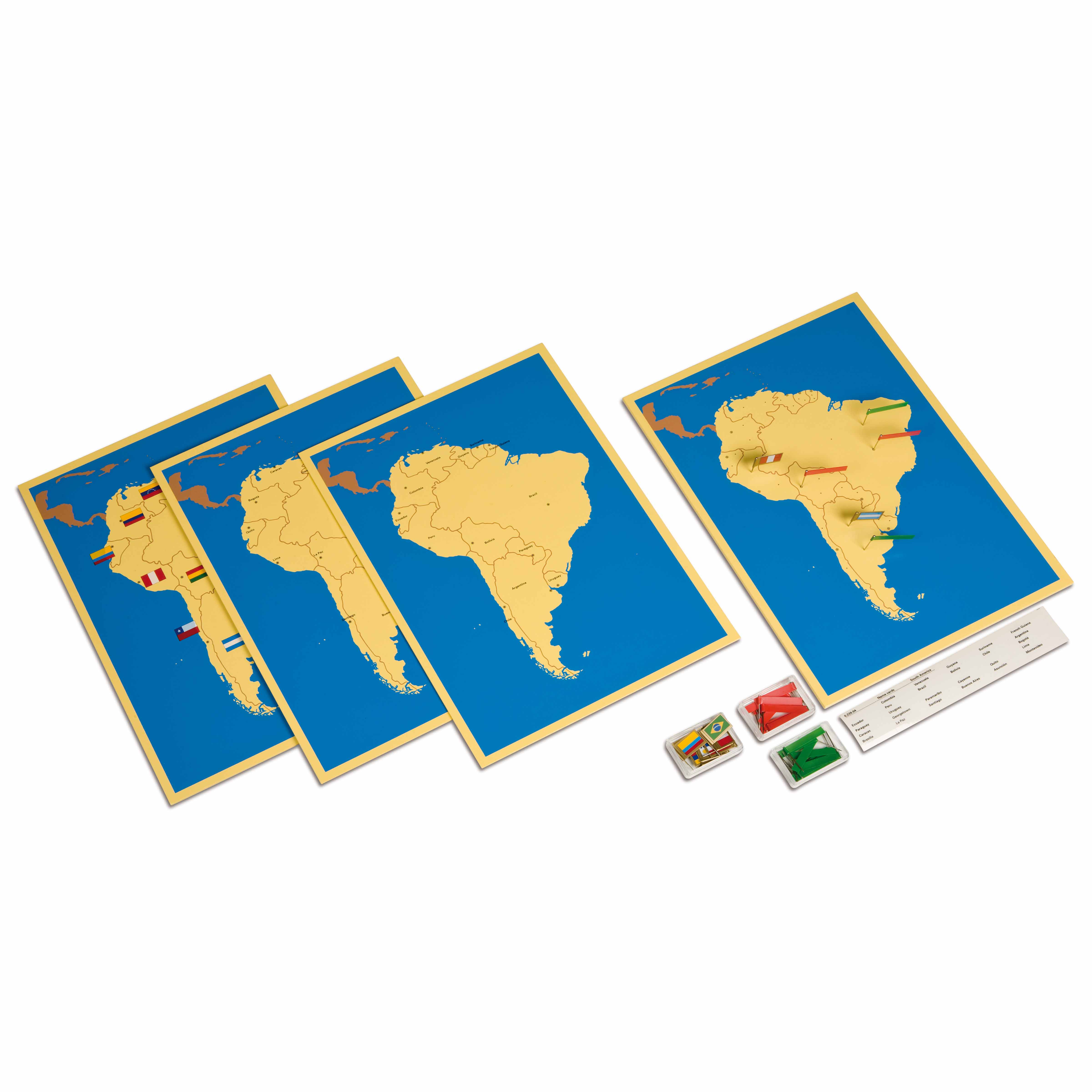
This set includes four distinct puzzle maps of South America: a control map showing political boundaries with countries labeled, an unlabeled political map for assessment, a capital cities map, and a physical features map highlighting major geographical elements like mountains, rivers, and terrain.
Each country is a separate wooden puzzle piece that children can remove and trace, helping them internalize shapes and boundaries through tactile exploration. This hands-on approach engages multiple senses, making it easier for young children to remember country locations and develop fine motor skills simultaneously.
The set includes labeled cards for country names, capital cities, and flags, along with control cards for self-correction. These materials allow children to match labels to countries, practice reading, and work independently while building their knowledge of South American geography.
The maps are designed with young children in mind, featuring smooth wooden pieces sized for small hands and simplified political boundaries. The concrete, manipulative nature aligns with how preschoolers learn best - through touch and movement rather than abstract concepts.
This material follows the Montessori progression from concrete to abstract learning. Children first explore the physical puzzle pieces, then connect them to names and symbols, gradually building a comprehensive understanding of South American geography that prepares them for more advanced cultural studies.
Can't find what you're looking for?
Contact Our Experts
Share your experience with this material and help other educators and parents.

