The North America Control Map: Labeled is a category.geography Montessori material designed for children aged 3-6, crafted by Nienhuis Montessori to AMI standards.
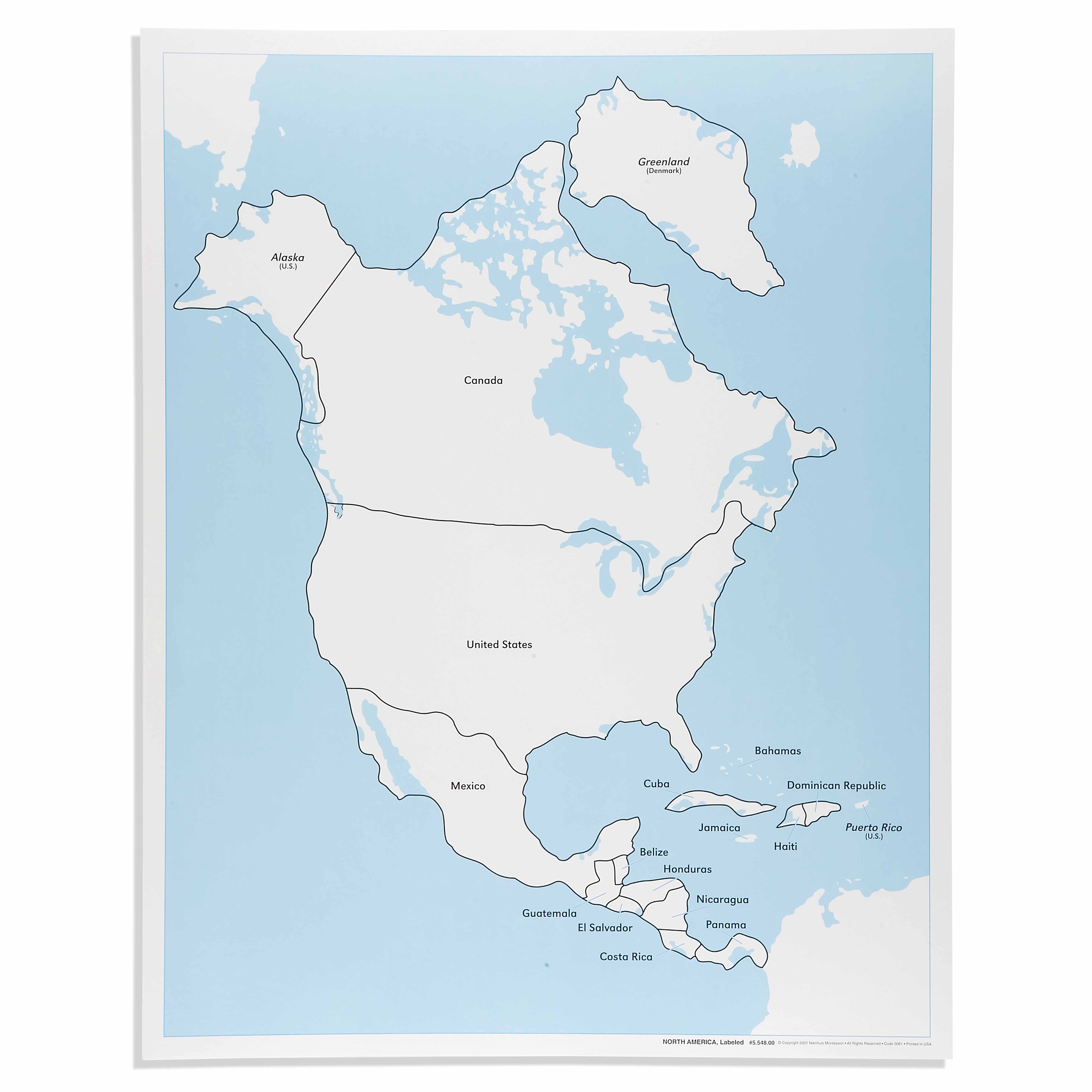
This labeled control map of North America serves as an essential reference tool in the Montessori geography curriculum, allowing children to verify their work with the unlabeled puzzle map. The durable laminated surface displays all countries, territories, and major water bodies with clear black outlines and precise labeling, supporting independent learning and geographical literacy development.
“Education is a natural process spontaneously carried out by the human individual, and is acquired not by listening to words but by experiences upon the environment.”— Maria MontessoriEducation for a New World
“The child is both a hope and a promise for mankind.”
— Maria Montessori, Education and Peace
The North America Control Map serves as a concrete key to geographical knowledge, enabling children to verify their puzzle work independently. This laminated reference map transforms abstract political boundaries into tangible learning experiences through its clear black outlines and precise country labels. In Montessori geography, control maps like this North American reference fulfill the child's need for exactness while building confidence in self-correction. The map's durable surface withstands repeated handling as children trace boundaries, locate countries, and match puzzle pieces to their corresponding regions. By providing immediate visual feedback, this control map eliminates the need for adult intervention during geography work. The labeled format bridges sensorial exploration with language acquisition, as children naturally absorb country names while checking their puzzle placement. This North America map exemplifies how Montessori materials honor the child's drive for independence by providing tools for self-verification and meaningful repetition.
Each order includes everything needed for proper presentation and long-term use.
Follow the Montessori method of presentation for optimal child development.
Complete the unlabeled puzzle map, placing each country piece
Bring the control map beside your completed puzzle
Point to each puzzle piece and find its match on the control map
Read the country name aloud from the control map
Check if any pieces need repositioning based on the control map
Every material is carefully selected for durability, safety, and authentic Montessori experience.
Sourced from sustainably managed European forests. Beechwood is chosen for its exceptional durability, smooth grain, and natural warmth that invites touch.
Natural, unbleached cotton in child-friendly colors. The fabric provides the right amount of friction for developing fingers while being gentle on sensitive skin.
Water-based, child-safe finish that meets the strictest European safety standards. Designed to withstand years of daily use without chipping or peeling.
Each material supports multiple areas of child development simultaneously.
Children develop spatial awareness and learn to identify countries, territories, and their relationships within North America.
Exposure to country names supports early reading skills and vocabulary expansion through meaningful context.
Serves as a control of error, enabling independent verification when working with unlabeled puzzle maps.
Introduces children to the diversity of nations and territories, fostering global consciousness and respect for different cultures.
Designed for child-sized hands
Professional tips from AMI-trained guides to maximize the educational value of this material.
“Introduce the control map only after children show proficiency with the puzzle map to maintain challenge”
Model precise finger movements when tracing boundaries to develop careful observation habits
Store the control map separately from the puzzle to encourage memory work before verification
Use three-period lessons with the map to solidify country names and locations
Everything you need to know about this material.
The labeled control map serves as a reference tool that allows children to independently check their work when using the unlabeled puzzle map. It promotes self-correction, builds confidence, and supports the development of geographical knowledge through visual matching and reading practice.
This control map displays all North American countries, territories, and major water bodies with clear black outlines. Each region is precisely labeled with its name, making it easy for children to identify and learn the names of countries like Canada, United States, Mexico, and Caribbean nations.
The map features a high-quality laminated surface designed to withstand frequent handling by young children. The lamination protects against spills, tears, and general wear, ensuring the map remains a reliable classroom resource for years of daily use.
Children can begin using this control map around age 3, typically after they've been introduced to the sandpaper globe and continent globe. The map supports learning through age 6 and beyond, growing with the child as they develop reading skills and geographical understanding.
This control map works in conjunction with the unlabeled North America puzzle map, pin maps, and flag work. It bridges sensorial exploration with abstract learning, supporting the child's progression from concrete manipulation to abstract geographical concepts and cultural studies.
Can't find what you're looking for?
Contact Our Experts
Share your experience with this material and help other educators and parents.


