The Oceania Control Map: Labeled is a category.geography Montessori material designed for children aged 3-6, crafted by Nienhuis Montessori to AMI standards.
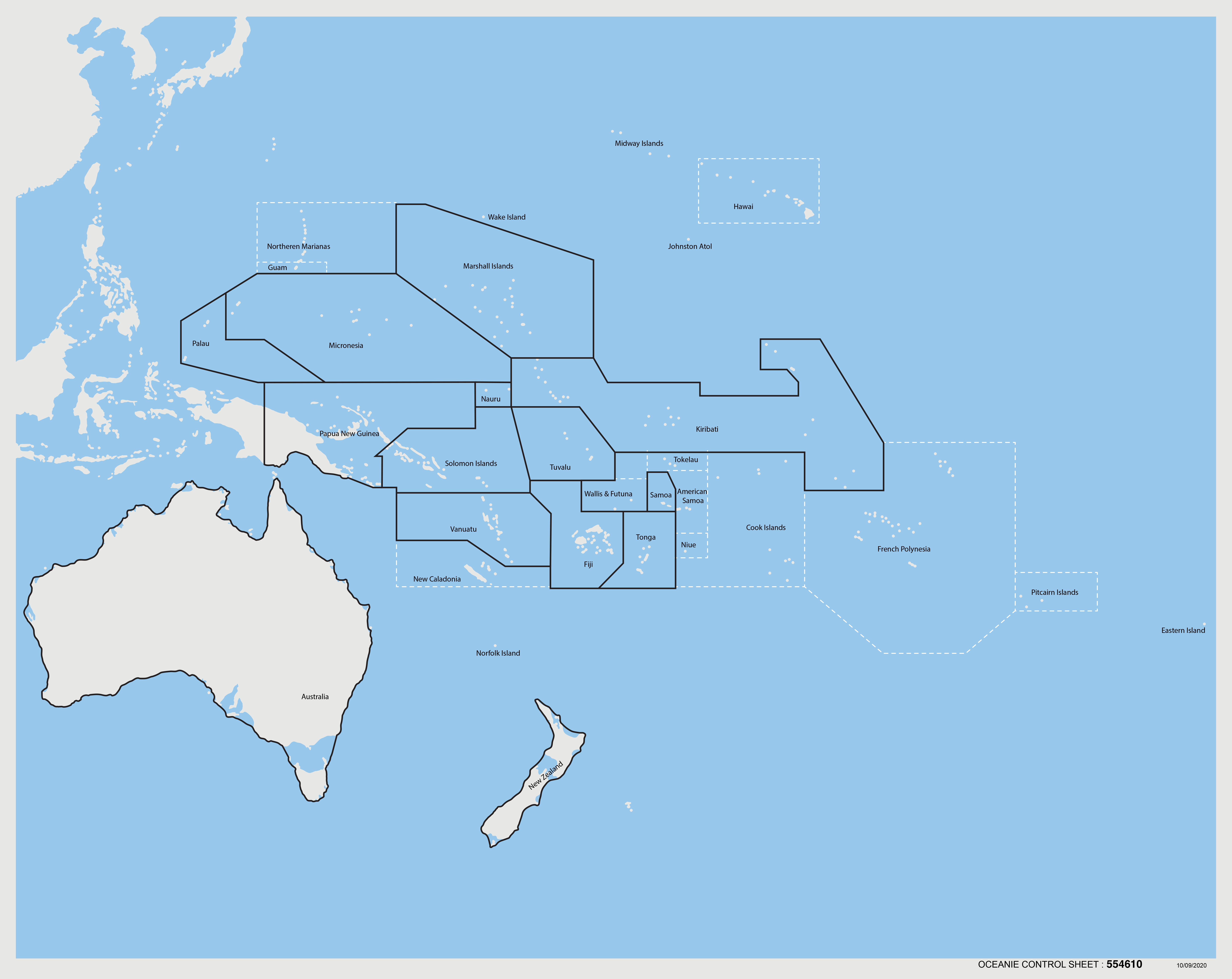
This labeled control map of Oceania introduces children to the political geography of the Pacific region through clear country boundaries and precise labeling. The laminated surface features nations and territories outlined in dark blue, with dotted lines indicating maritime boundaries and territorial waters. Designed to accompany the Oceania puzzle map, this reference material supports independent work and self-correction in geography studies.
“Education is a natural process spontaneously carried out by the human individual, and is acquired not by listening to words but by experiences upon the environment.”— Maria MontessoriEducation for a New World
“The child is both a hope and a promise for mankind.”
— Maria Montessori, Education and Peace
The Oceania Control Map serves as a concrete reference point for children exploring Pacific geography through its precise country boundaries and clear labeling. In Montessori geography, control maps provide the exact information children need to verify their work independently, eliminating reliance on adult correction. The dark blue outlines on this laminated map create visual clarity that helps young minds distinguish between nations and territorial waters. When children trace these boundaries or locate specific countries, they absorb geographical relationships through repeated visual exposure. The dotted maritime lines on this control map introduce concepts of territorial sovereignty in ways three-to-six-year-olds can visually comprehend. By offering labeled countries and territories, this map transforms abstract political boundaries into concrete learning experiences. The laminated surface ensures durability for countless consultations as children build their mental map of Oceania through independent exploration and verification.
Each order includes everything needed for proper presentation and long-term use.
Follow the Montessori method of presentation for optimal child development.
Demonstrate how to carry the control map with two hands to the work area
Show how to unfold and smooth the map on the work surface
Point to one country, read its label aloud, then trace its boundary with your finger
Invite the child to choose a country and repeat the process
If using with puzzle map, demonstrate comparing puzzle piece to control map location
Every material is carefully selected for durability, safety, and authentic Montessori experience.
Sourced from sustainably managed European forests. Beechwood is chosen for its exceptional durability, smooth grain, and natural warmth that invites touch.
Natural, unbleached cotton in child-friendly colors. The fabric provides the right amount of friction for developing fingers while being gentle on sensitive skin.
Water-based, child-safe finish that meets the strictest European safety standards. Designed to withstand years of daily use without chipping or peeling.
Each material supports multiple areas of child development simultaneously.
Builds understanding of Oceania's political divisions and island nations through visual recognition and spatial relationships.
Enriches vocabulary with country names, capital cities, and geographic terminology specific to the Pacific region.
Develops ability to distinguish boundaries, recognize shapes of nations, and understand territorial relationships.
Serves as a control of error, allowing children to self-check their work with the unlabeled puzzle map.
Designed for child-sized hands
Professional tips from AMI-trained guides to maximize the educational value of this material.
“Display the control map at eye level when wall-mounted to encourage spontaneous reference during other activities”
Create a basket of Oceania landmark cards that children can match to countries on the control map
Use the maritime boundary lines to introduce discussions about ocean territories and fishing rights
Rotate focus weekly between different island groups to prevent overwhelm with numerous small nations
Everything you need to know about this material.
This control map displays all major countries and territories in Oceania, including Australia, New Zealand, Papua New Guinea, Fiji, Solomon Islands, Vanuatu, and other Pacific island nations. Maritime boundaries and territorial waters are shown with dotted lines to help children understand the political divisions of the Pacific region.
The control map serves as a reference guide for children working with the Oceania puzzle map, enabling independent work and self-correction. Children can compare their puzzle work to the labeled map, building confidence and accuracy in identifying countries. This aligns with Montessori principles of self-directed learning and control of error.
The map features clear, simple country boundaries outlined in dark blue, making it visually accessible for young children. The laminated surface is durable for frequent handling by small hands, and the labeled format provides concrete visual support as children begin to associate country shapes with names during their sensitive period for language and order.
Children use this map alongside the Oceania puzzle map to check their work, learn country names, and explore Pacific geography. They may trace countries, create their own maps, or use it for three-period lessons. The map also supports extensions like researching animals, flags, or cultural elements from different Oceanic countries.
This is a laminated control map designed for durability in classroom use. The laminated surface allows for easy cleaning and protects against spills or tears. The map uses clear dark blue outlines for country boundaries and includes dotted lines for maritime boundaries, making political divisions easy to distinguish.
Can't find what you're looking for?
Contact Our Experts
Share your experience with this material and help other educators and parents.


